★ Win a pair of Brandecosse Capriolo boots worth £219! Click here to enter ★


Free Deer Collisions app will help to map deer casualties
Deer Collisions Oh Deer! App: Deer Collisions, a project that monitors and researches road traffic accidents involving deer, has launched a free smartphone app that allows users to log deer road casualty locations.
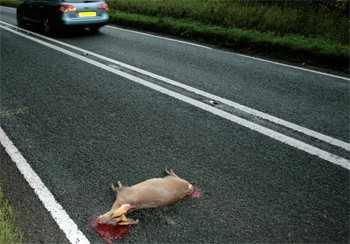
The ‘OhDeer!’ app will help to map deer casualties throughout Britain and will allow users to view data submitted by other users.
The number of road accidents involving deer is estimated to be more than 42,000 a year in Britain, but most are not recorded. Information logged via the app will assist research on the number and location of accident hotspots.
The app is expected to be of particular use to those attending deer at the roadside for despatch, because it will allow an accurate GPS location.
Once the GPS information is obtained, it does not matter whether there is phone network access because the information is stored in the phone and can be uploaded to the project website when the user is back in network range.
Deer Collisions advises people not to use the app while driving, but to allow a passenger to do so or to stop if it is safe and legal to do so.
Alternatively, users can make a mental note of the location so that they can enter the record online at a later date.
To download the app, visit bit.ly/16X9Ibp and follow the instructions.
Say what you think in the Shooting UK forums!
Deer Collisions Oh Deer! App
Related Articles
News
Shooting app puts a score on the day
The new TopGun app allows game shots to digitally track performance, record shoot days and compete on national leaderboards.
By Hollis Butler

News
Nick Beavis wins sixth BASC .410 world title
Staffordshire shooter Nick Beavis has won his sixth BASC .410 World Championship title at Oakedge Shooting Ground.
By Hollis Butler
Get the latest news delivered direct to your door
Subscribe to Shooting Times & Country
Discover the ultimate companion for fieldsports enthusiasts with Shooting Times & Country Magazine, the UK’s leading weekly publication that has been at the forefront of shooting culture since 1882. Subscribers gain access to expert tips, comprehensive gear reviews, seasonal advice and a vibrant community of like-minded shooters.
Save on shop price when you subscribe with weekly issues featuring in-depth articles on gundog training, exclusive member offers and access to the digital back issue library. A Shooting Times & Country subscription is more than a magazine, don’t just read about the countryside; immerse yourself in its most authoritative and engaging publication.