Free Deer Collisions app will help to map deer casualties
The ‘OhDeer!’ app will help to map deer casualties throughout Britain and will allow users to view data submitted by other users.
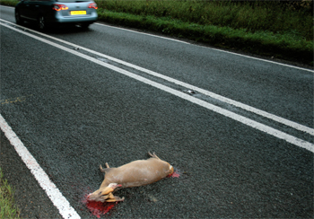
The number of road accidents involving deer is estimated to be more than 42,000 a year in Britain, but most are not recorded. Information logged via the app will assist research on the number and location of accident hotspots.
The app is expected to be of particular use to those attending deer at the roadside for despatch, because it will allow an accurate GPS location.
Once the GPS information is obtained, it does not matter whether there is phone network access because the information is stored in the phone and can be uploaded to the project website when the user is back in network range.
Deer Collisions advises people not to use the app while driving, but to allow a passenger to do so or to stop if it is safe and legal to do so.
Alternatively, users can make a mental note of the location so that they can enter the record online at a later date.
To download the app, visit bit.ly/16X9Ibp and follow the instructions.
Say what you think in the Shooting UK forums!
Deer Collisions Oh Deer! App